Map E2
find your own way below White Tor awkwardly missing several
small bogs heading down Cudlipptown down to gate set back into a
corner of moor wall. Inside gate is a useful & pleasant place to
stop and picnic. Then down bridle path for 300m usually watched
by the horses in adjacent fields to the lane .
OK, so now you are asking as I did, why aren’t we
going up north along the moor wall to Standon Hill? The answer
is beyond Lynch Tor is poor/bad/ rocky ground and not
recommended. We are researching that area but that is best
advice so far. Also this route avoids the army ranges.

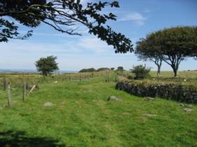
E2 Moorgate below Cudlipptown Down SX 539 798
At Wapsworthy, Turn left (west)onto lane along
500m and then turn
right downhill (north)for 400m to Hillbridge. A very
pretty spot with Mill pond and take off point for the Mary Tavy
Hydro electric Leat.
Just beyond the bridge is the choice of staying on the lane (north)taking Route R – Rattlebrook in good weather (check army range on 0880 4584868) or turning left West on the Public Bridleway which follows a pretty route through a small farm.
Wiggly old lanes to a gate which opens onto open access land go 100m to turn left South joining lane( or ,go about 1km down lane south west to Elephants nest Inn at Horndon 01822 810273 for 100m and then turn off lane right(north) on a clear public bridle path for 300m through gate and narrow green lane for 200m

Leave through gate then
continuing North straight ahead on clear bridle path track
across tufted heath land for 500m past Wheal Jewel reservoir on
right East then turn half left on track Northeast to
Map
E1
& after 300m and crossing a brook you can turn left West to take the Route L Lydford Village Detour or continue straight approx North for 300m and turn right Northwest heading for the corner of the moor wall about 500m North.
Good Parking (inc lorries) just west of here SX 517 834 just off the A386 Soon you notice army range red and white posts(firing info 088 458 4868) , which you will now skirt for 1500m.( on reaching the moor wall, keep N and follow track for 500m until it turns right E to Map E2

E2
Track near Wheal Jewel reservoir SX 522 815
Follow good track 1000m approx East looking up towards the Tors and cross the wallabrook at the second and higher crossing at SX 537 845,then head up rightish approx North East over Doe Tor for about 400m and cross Doetor brook at SX……..(To be added) and Map F2 heading now for about 600m North west to cross the bridleway and Route L coming from Lydford at the ford.
Good Parking for trailers only up narrow lane just north of Dartmoor Inn. Excellent Horse B&B voted five stars by us at Lydford House Hotel 01822 820347 about 1km off the moor.

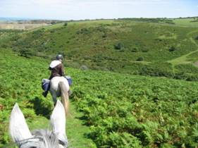
F2 Looking back down river Lyd SX 532 857
If time and weather allow ride up to Bray Tor and Widgery Cross and it is fairly easy to rejoin the route beyond Great Links Tor.
You are entering wonderful country
now.
Head now north for 600m on the east bank of the Lyd and cross left(west) at the ford and after 50m join and turn right(north west) on a good track that will take you easily for the next 5km in the same direction.

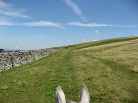
F2 Crossing ford on River Lyd SX 535 864
You can relax now, take photos of your companion if you have one, hopefully they are as fine a site as the scenery.
The Tors high above you are quite magnificent perhaps the best group on the moor
Ahead lies Great Noddern .This is a unique sensually smooth rounded hill which drops steeply down to the Lyd.

F2 up track to Great Noddern SX 535 865
After about 2km and past Great Noddern the track continues gradually gaining height . It easy to ride along the side of most and fit outfits can gather speed here
At SX 543 884 approx Route R rattlebrook track joins from the right(east)

F2 track beyond Great Noddern SX 544 880
After 500m more approx Sourton Tors come into view about 1Km distant and the hard track turns to an easy grass track which is simple to follow with Corn Ridge gently above you on the right(east)

Well equipped trekking outfit. Portuguese horse used to the moor and physically fit.
On a very hot day Rider
is wears deluxe hi tech riding hat with
big cooling vents. Map
case easy to hand. panniers fit well but are of a day trip
budget type (about £20) started falling apart after 3 full days.
Rider wears towel round neck to ward off sun and masses of sun
cream having gone red the day before. A Reminder on Hot

F2 Well equipped trekking outfit SX 544 890
Great place for a gallop ….
Wonderful ground above Sourton Tors
Also good parking near Prewley Water works at SX 545 909
Also easy access from A30 …
…..In fact a rather place to enjoy your horse!
F2 Wonderful turf ! SX 545 895
Meldon reservoir comes into view and you head easily down on clear track northwest towards a gate on the Dartmoor Way tucked into a corner at SX 550 907
You are asking now why we are not heading further south right of the reservoir into the exciting hill country. Well its very steep, several bogs and bad areas. Perhaps go there another time with someone sensible who knows the way… we’ll play safe and enjoy the ride..

Looking NW towards reservoir SX 545 896
Through the gate is lovely riding North west on old turf between walls for 600m until finger post where you take bridleway turning rightish through scrub for a couple of hundred metres
F2 lovely just off moor ride SX 552 912
Here are useful
toilets, small amount of
parking for trailers
(busy in season) & an ice
cream van.
Dam is impressive and clatter across road over it and
along a little way before turning sharp right back up steep
track east onto good grass going and on to
Map G3

G2 Reservoir & Longstone Hill SX 562 917
t the top of the hill head
slightly left
You will now be heading approx east for 7 km on easy ground, good tracks lovely turf beside with views of the high Tors to the south., just wonderful really…..makes up for getting lost at…. And falling in the bog at…enjoy you’ll be lost again soon.
G3 towards Red-a-ven Brook SX 567 915
Leaving the brook head
up hill east and now follow the wall for about 1500m, room to
spread out on super ground and go…. Keep the Army range flags to
your right(firing info 088 458 4868)
Soon you can decide if: you have time, horses the energy and the army range is open to detour up the highest Tors on the Moor..
G3 good ground on Black Down SX575 921
If you decide to go up the easiest way is turn right up the next army road south and go about 3km on it right up to Yes Tor and High Willhays.
You can pick your way up overland but it is rocky.
Breathtaking views ..top of the world etc, just got to be done…

G3 north from High Willhays SX581 895
Staying on the route
You may be lucky and see the herd of miniature ponies that sometimes are out on Black Down

G3 miniature ponies,Black Down SX585 921
Okehampton Battle camp appears soon on the left north. Well screened by a shelter bed. Photo view is from the other side.
The writers view is that the army prescence is to be welcomed on the moor. Our country is bloody well worth defending. Our boys and girls need training and what a great place to do it. Info on when the ranges are open is readily available 088 458 4868. and we have designed the route C to go round it. Anyway they have the worst ground and most of the year they are welcome to it….

G3 south over army camp SX591 935
Cross the first of several army tracks and then Moor Brook going on east again up the other side.
Here is shown how to keep your hosses cool on a sweltering day. A small folding camping bucket 99p from bargain £1 shop and an endurance sponge on a rope are all that’s needed. Chuck loads all over including yourselves and it keeps them cool for quite a while. Do at every stream if necessary. If the bucket is yellow that’s handy for seeing when you lost back at….

G3 Cooling off, MoorBrook SX 588 924
Beyond Moorbrook is easy, gently rising ground, crossing another army track to the ridge.
Look rightish
South East now and head down 500m down to the
G3 Easy ground S of camp SX 595 925
Here near the ford at Cullever steps is an excellent picnic stop. The two greys here are tethered by ropes above to overhanging branches. They and their riders enjoyed the shade and a gentle doze ,they had been working hard. These two get on well and are trained to be tied in odd places. It is a good way but needs training otherwise they will break the trees and get away. Remember one loose horse may not matter…two may well do so big time … I have walked for miles home….so I know..

G3 Picnic at Cullever steps SX 605921
Refreshed, move-em on up and out north east now for 1.5km up a small track through scrub on the north side of Belstone Common.
After a while it clears to better grass and on to map G4

G3 scrub on Belstone common SX 612 928
When nearing the hill top keep a lookout about 100m right, east for the small nine maidens stoneCircle.
What a great spot….you can believe one of the stories or make up your own ..nine maidens fell in love with one (lucky) man…..they spent all night deciding who was going to have him ,failing in their task they were found frozen to death in the morning… what a waste …ah well..

G4 Nine maidens stones approx SX 612 928
Don’t let the previous lovely sunny pictures of riders having fun when just about everything went right fool you….frankly that’s exceptional
The mist can come in, it can get very dark very early in the day…..and you can get frightened ,they call “pixie led” if you get lost even for just a few minutes
Be warned, be prepared….do take that coat, extra top, compass….

G4
Back on the sunny day you pass the army flagpole on watchet hill and then head down North West to Belstone Village to find the moor gate at SX 616 933.
There are other ways down avoiding the village but this is easy and interesting.
A brief walk down the lane leads into the centre of the village and at the pub go south back towards the moor onto the village green.

G4 Army flagpole watchet Hill SX 615 931
Now this is a good place…First excellent level Parking inc for lorries just by the entrance to the village. which is easily accessible from the A 30.then there is the Tors pub 01837 840689 which has tables on the green where you can sit with your horse with a splendid view..bliss …if only there were more like this. A mile away is the excellent Skaigh Riding stables 01837 840429. I think there may be a shop as well..
Leaving this treasure head down the far edge of the green south west …

G4
Belstone Village green SX 620 933And find what a pretty ford ,popular with paddlers in the dapple shade. The last water for a while so cool your horse down if its hot …
Following the track out and uphill though scrub and copse to the other side for about 200m the track divides, you take the left one and then left offshoot south west and this takes you up and out on a clearly visible green track all the way up 1km towards the beacon then turning slightly right almost due south to the summit

G4 River TawFord at Belstone SX 622 933
Don’t take the right hand track and leave the copse going south closer to the river Taw. We did and it is horrible, straight into bogs and poor ground .best to retrace, we didn’t and groaned our way back to the right path further east,
Hey I thought we were writing this guide…
Just shows how quickly you can go wrong, broad sunny daylight, chatting away .. straight into a bog.. you’ll do the same

G4 Wrong route to Cosdon SX 624 930
Again what not to do…
It was hot, Cosdon looked high, thought we’d spare the hosses and skirt around east near the wall.. bad idea… awful ground ,lots of bogs and rocks. now marked “avoid” on map G4.
If the mist comes in to follow the bridle path track east and off the moor and go on the pretty lanes along to Throwleigh
But back on Cosdon on a good day. Wow!, you can tie up to the trig point and enjoy views as afar as…
To add photo Cosdon Beacon
Taking a 90 degree right from the way you came up ,head west and downwards

G4
Here is the a rare triple row locally known as the “graveyard”.

G4 triple row the “graveyard” SX 643916
Here turn right and head south west keeping the Cheriton brook on your right for 600m and cross the Blackaton Brook.
You are then on Throwleigh Common heading again south west for about 1km towards Buttern Hill beyond.
Not far from here is good horsebox Parking
Inc lorries at Paines Bridge SX658 914 an easy drive up a lane from the South Zeal main road
crossing a small brook you are now near the moor wall and on to Map F4

F4 looking back over Throwleigh Common


Continuing along the forest track south are soon good
parking and toilets and further along is a picnic table
area and trees to tie up the horses.( a proper tie rail
would be really useful here).Continue south along the
track about a mile through various gates and Laughter
Hole farm until the gate to open moor. Here take the
left hand track south
east to:
Map D4
follow track which
now goes south for a mile to corner of Snider park
Forest and then follows Forest wall
down to gate which opens onto the busy B 3357
regrettably you have to follow this for about 400m but
it is a straight reasonably visibility stretch and turn
right onto much quieter lane to Hexworthy and:
